ÚVOD
Webový portál www.doprava-brno.cz je součástí Dopravního informačního centra Statutárního města Brna. Portál obsahuje informace o aktuálním dění na pozemních komunikacích na území města Brna a Jihomoravského kraje. Informace o stavu dopravy jsou získávány
- z dat flotily vozidel společnosti Princip a.s.
- z dat kamerových strategických detektorů instalovaných na území města Brna v počtu 98 kusů
Portál dále poskytuje aktuální informace o uzavírkách, dopravních nehodách, apod. získávaných z Dopravního informačního centra Brno a Národního dopravního informačního centra v Ostravě.
Portál také poskytuje informace stavu telematických zařízení ve městě Brně:
- aktuální obsazenost vybraných parkovišť
- aktuální stav řadičů světelných signalizačních zařízení
- aktuální stav průjezdnosti tunelů
Dopravní informace je možné získat i prostřednictvím mobilní aplikace pro operační systém Android a Apple.
FLOATING CAR DATA
Floating Car Data (FCD) jsou informace o stavu dopravy, které jsou generovány na základě aktuální poloze vozidel z flotily vozidel firmy Princip.
Data jsou odesílána z každého vozidla na aplikační server k vyhodnocení. Síť dopravních komunikací je rozdělena na úseky podle lokalizační databáze.
Ta popisuje většinu důležitých komunikací využívaných pro běžný provoz. Jeden její úsek nejčastěji odpovídá vzdálenosti dvou křižovatek komunikací,
které mají nezanedbatelný vliv na rozložení dopravního proudu. Na základě informace o poloze vozidla v čase je na těchto úsecích vyhodnoceno dopravní
zatížení na stupnici od jedné do čtyř, kde stupeň jedna znamená minimální zatížení komunikace neboli běžnou rychlost dopravního proudu,
a stupeň čtyři představuje maximální zatížení komunikace odpovídající kolonám.
Mapa zobrazuje pouze aktuální vypočtená data. Úseky, na nichž není k dispozici platná vypočtená hodnota nebo je hodnota starší než 10 minut, nejsou viditelné.
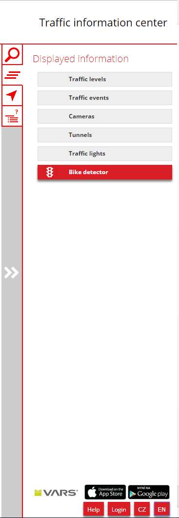
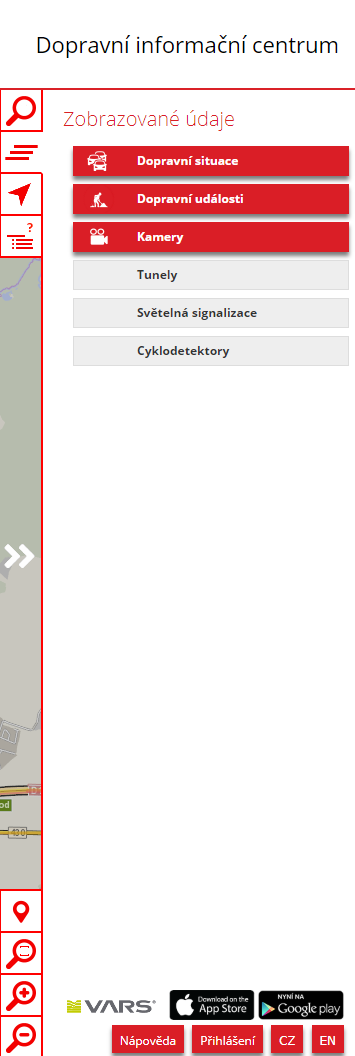
ROZLOŽENÍ APLIKACE
V pravé horní části aplikace je umístěno menu pro ovládání aplikace. Lze přepínat viditelnost jednotlivých vrstev, vyhledat administrativní jednotku
a zadat zájmový úsek pro stanovení dojezdové doby z místa A do místa B.
Ve spodní části je možné zvolit jednu ze dvou jazykových verzí aplikace. Také je zde možné přihlášení registrovaného uživatele státní správy.
![]()
ZOBRAZENÍ POSKYTOVANÝCH INFORMACÍ
Dopravní situace
Dopravní situace je mapě znázorněna pomocí linií – barevně odlišených úseků se čtyřmi stupni dopravy:
![]() Běžná rychlost odpovídá stupni dopravy číslo 1 a 2
Běžná rychlost odpovídá stupni dopravy číslo 1 a 2![]() Snížená rychlost odpovídá stupni dopravy číslo 3
Snížená rychlost odpovídá stupni dopravy číslo 3![]() Pomalá rychlost odpovídá stupni dopravy číslo 4
Pomalá rychlost odpovídá stupni dopravy číslo 4![]() Kolona odpovídá stupni dopravy číslo 5
Kolona odpovídá stupni dopravy číslo 5
Maximální stáří zobrazovaných informací je 10 minut od jejich vzniku.
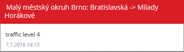
Ukázka zobrazení dopravní zátěže v mapě
![]()
Po najetí kurzoru na úsek dopravní zátěže systém zobrazí tooltip s hodnotou stupně dopravy
![]()
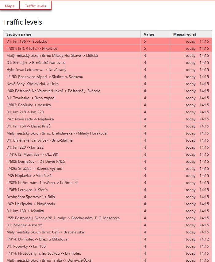
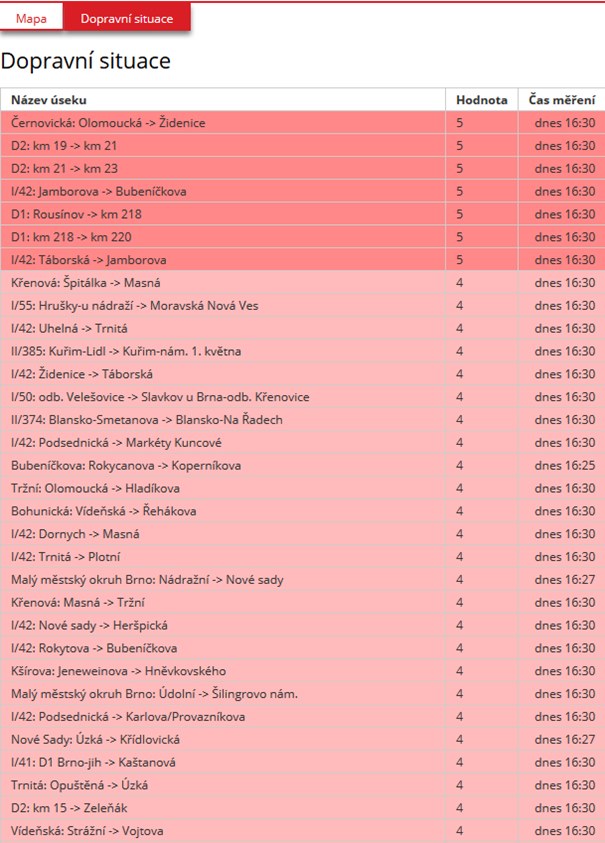
Aplikace poskytuje tabelární zobrazení úseků dopravní zátěže s aktuální hodnotou stupně dopravy.
![]()
Dopravní události
Aplikace zobrazuje dopravní informace dělené do těchto kategorií:
![]() Nehody
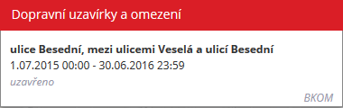
Nehody![]() Uzavírky a omezení
Uzavírky a omezení![]() Dopravní situace
Dopravní situace![]() Práce na silnici
Práce na silnici![]() Sjízdnost vozovky
Sjízdnost vozovky![]() Nadměrný náklad
Nadměrný náklad![]() Parkování
Parkování![]() Ostatní
Ostatní
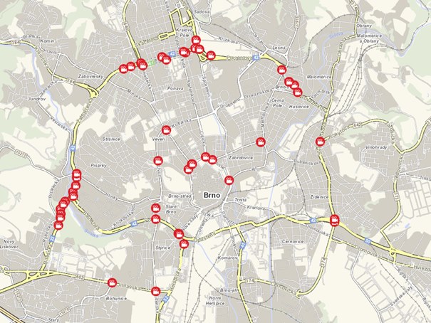
Ukázka zobrazení dopravních událostí v mapě
![]()
Po najetí kurzoru na ikonu se zobrazí tooltip s detailem dopravní události
![]()
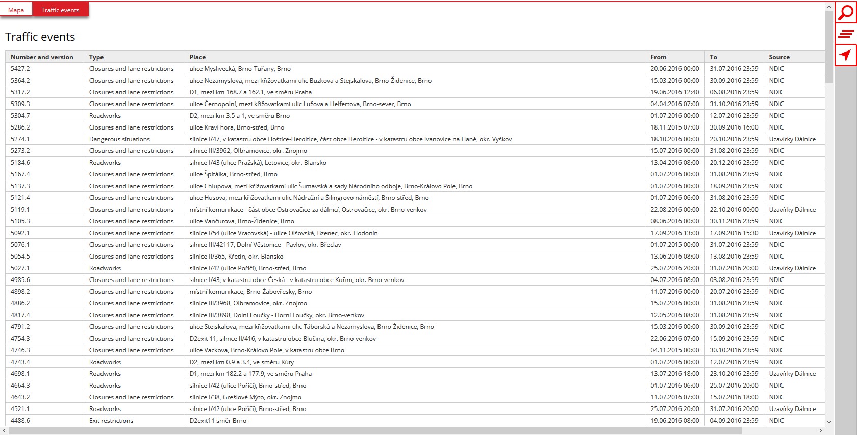
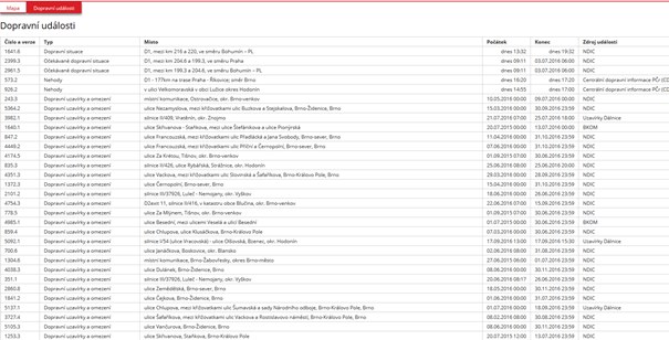
Aplikace poskytuje tabelární zobrazení dopravních událostí.
![]()
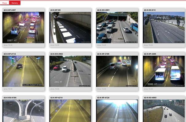
Kamery
Aplikace zobrazuje přehled kamer z dohledového kamerového systému ve městě Brně.
![]()
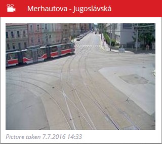
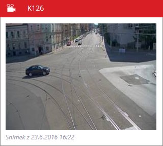
Po najetí kurzoru na ikonu se zobrazí tooltip s aktuálním statickým snímkem kamery.
![]()
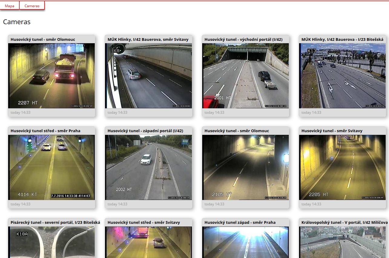
Snímky z kamer jsou k dispozici také ve formě dlaždic
![]()
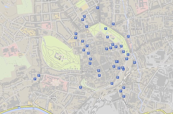
Parkovací místa
Aplikace zobrazuje bodovou vrstvu přehled evidovaných parkovacích lokalit v mapě
![]()
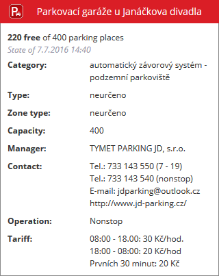
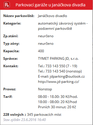
Po najetí kurzoru na ikonu parkovací lokality aplikace zobrazí detailní informaci o lokalitě
![]()
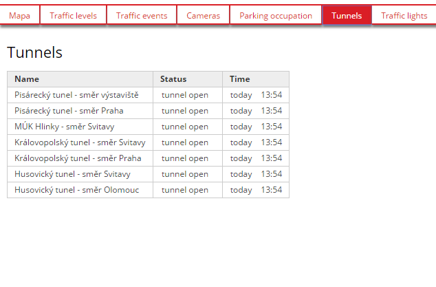
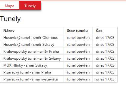
Tunely
Přehled tunelů ve městě Brně. Každá tunelová trouba je reprezentována samostatnou ikonou.
Tunel může nabývat těchto stavů:
![]() Tunel otevřen
Tunel otevřen![]() Provoz v tunelu omezen
Provoz v tunelu omezen![]() Obousměrný provoz
Obousměrný provoz![]() Tunel uzavřen
Tunel uzavřen
![]()
![]()
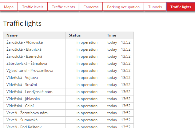
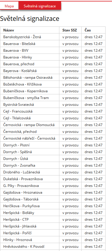
Světelná signalizační zařízení
Aplikace zobrazuje bodovou vrstvu přehled světelných signalizačních zařízení. SSZ může nabývat tyto stavy
![]() SSZ v provozu
SSZ v provozu![]() SSZ v poruše nebo mimo provoz
SSZ v poruše nebo mimo provoz
![]()
![]()
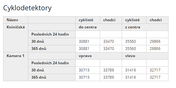
Cyklodetektory
Aplikace zobrazuje přehled cyklodetektorů ve městě Brně.
![]()
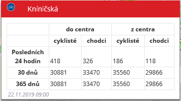
Po najetí kurzoru na ikonu detektoru se zobrazí tooltip s detaily o počtu cyklistů a chodců zaznamenaných příslušným detektorem za posledních 24 hodin, 30 dní a rok.
![]()
Aplikace poskytuje také tabelární zobrazení všech detektorů a jimi naměřených dat za dané časové období.
![]()
OVLÁDÁNÍ MAPY
Uvnitř mapového okna je umístěno několik ovládacích prvků.
Změna měřítka
Aktuální měřítko v mapě lze měnit několika způsoby:
- kliknutím na
![]() pro přiblížení mapy
pro přiblížení mapy
- kliknutím na
![]() pro oddálení mapy
pro oddálení mapy
- kliknutím na
![]() pro zobrazení celé mapy
pro zobrazení celé mapy
- dvojklikem myši do mapy (levé tlačítko myši mapu přiblíží, pravé oddálí),
- rolováním kolečka myši (od sebe - přiblížení, k sobě - oddálení),
- přiblížení na požadovanou oblast:
- kombinace kláves CTRL + levé tlačítko myši a vymezení požadované oblasti,
- pravé tlačítko myši a vymezení požadované oblasti.
Posun mapy
Výřez mapy je možno posouvat tažením myši se současně stisknutým levým tlačítkem.
VYHLEDÁVÁNÍ
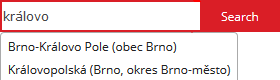
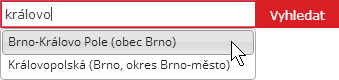
V pravé horní části mapového okna je umístěno pole pro vyhledávání.
![]()
Vyhledat lze ulici, město, okres, nebo městskou část na území města Brna Bezprostředně po stisknutí tlačítka „Vyhledat“ mapa zobrazí a zvýrazní hledanou ulici.
Jakmile uživatel napíše do vyhledávacího políčka první písmeno, aplikace začne nabízet seznam prvních dvaceti odpovídajících názvů ulic (obcí).
Zvolenou položku lze vybrat levým tlačítkem myši nebo pomocí kláves „Šipka nahoru“ a „Šipka dolů“ s potvrzením klávesou „Enter“.
![]()
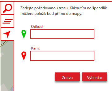
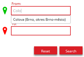
NALEZENÍ TRASY
Pomocí ![]() lze zpřístupnit funkci pro vyhledání trasy na území Jihomoravského kraje
lze zpřístupnit funkci pro vyhledání trasy na území Jihomoravského kraje
![]()
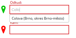
Uživatel může zadat počátek a konec požadované trasy pomocí editačních polí, nebo v mapě. Při psaní místa počátku nebo konce aplikace provádí našeptávání názvu
stejně jako při vyhledávání místa:
![]()
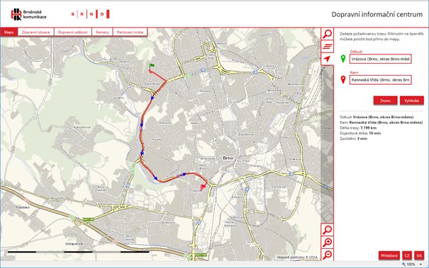
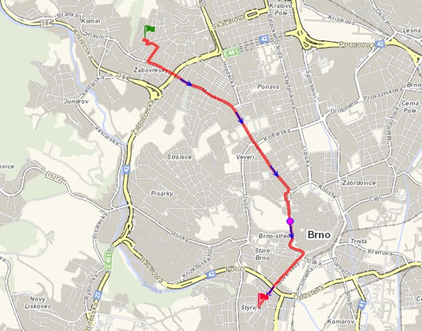
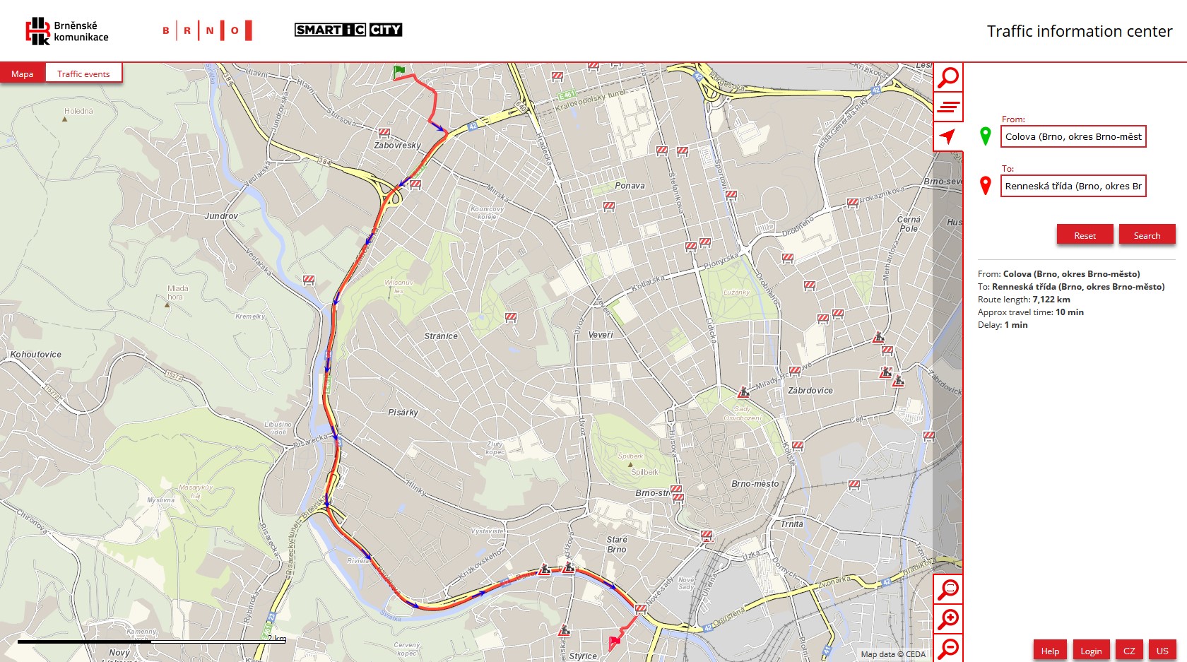
Nalezená trasa:
![]()
Systém poskytne informaci o celkové dojezdové době a o zpoždění na trase.
Průběh trasy lze ovlivnit přetažením libovolného místa na trase do požadované polohy
![]()

 ,
,


 Běžná rychlost odpovídá stupni dopravy číslo 1 a 2
 Snížená rychlost odpovídá stupni dopravy číslo 3
 Pomalá rychlost odpovídá stupni dopravy číslo 4
 Kolona odpovídá stupni dopravy číslo 5
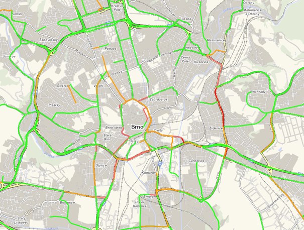

 Nehody
 Uzavírky a omezení
 Dopravní situace
 Práce na silnici
 Sjízdnost vozovky
 Nadměrný náklad
 Parkování
 Ostatní
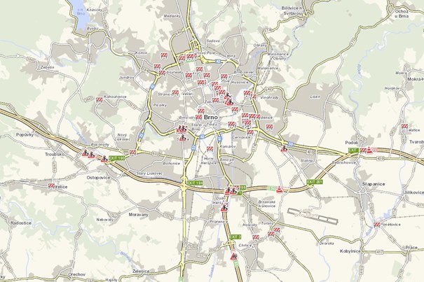
 Tunel otevřen
 Provoz v tunelu omezen
 Obousměrný provoz
 Tunel uzavřen
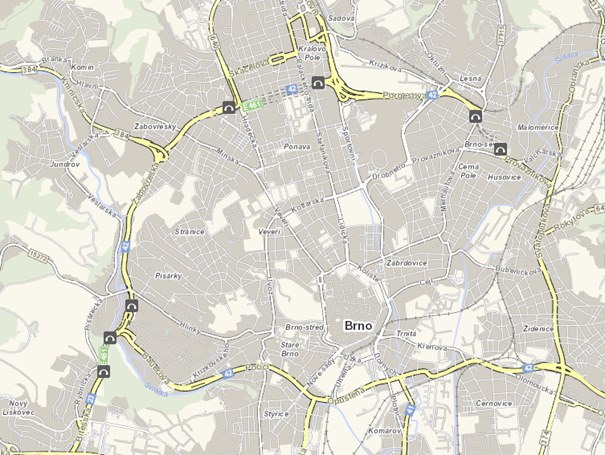
 SSZ v provozu
 SSZ v poruše nebo mimo provoz
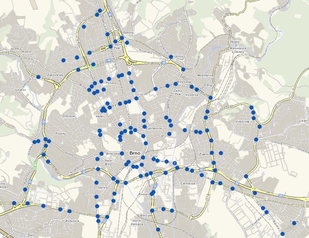
 pro přiblížení mapy
 pro oddálení mapy
 pro zobrazení celé mapy
 lze zpřístupnit funkci pro vyhledání trasy na území Jihomoravského kraje